Dyrholaey: A Guide to the High Cliffs and Basalt Arch of the South Coast
Dyrholaey
Weather
Local Time
A practical look at visiting Dyrholaey, from navigating the upper and lower parking areas to timing your visit for puffin season and managing the intense coastal winds.
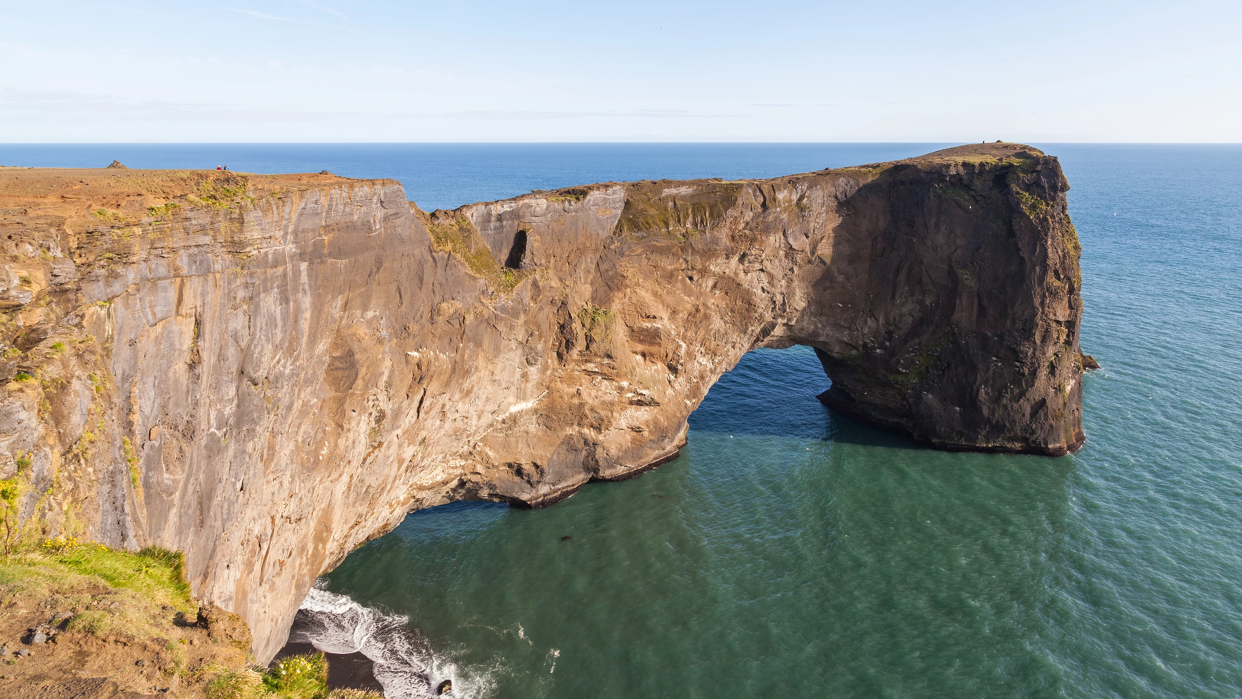
„Einstakur höfði, 110–120 m hár, með þverhníptu standbergi í sjó og að vestan, en meira aflíðandi og grasbrekkur að norðan. Suður úr henni klettatangi, Tóin, með gati í gegn, dyrunum sem eyjan ber nafn af, Dyrhólaey“ (1). Dyrhólaey var friðlýst árið 1978 en þar er mikil náttúrufegurð og fuglalíf og eyjan því vinsæll viðkomustaður ferðamanna. Umferð um friðlandið er opin almenningi nær allt árið, en er þó stýrt á varptímum til verndar fuglalífi (2).
Dyrhólaey, a massive promontory on Iceland’s southern coast, stands as a testament to the violent and creative power of submarine volcanism. Located near the village of Vík í Mýrdal, this 120-meter-high cliff is not merely a scenic stop along the Ring Road; it is a geological monument, a sanctuary for fragile ecosystems, and a site steeped in maritime history. Its name, which translates to "door hill island," perfectly captures its most striking feature—a colossal natural arch of black basalt that juts into the churning grey waters of the North Atlantic.
The Geological Foundation
The story of Dyrhólaey began approximately 100,000 years ago during the late Pleistocene epoch. It was formed by a series of subaquatic volcanic eruptions, a process similar to the birth of the island of Surtsey in the 1960s. As molten lava met the freezing sea, it cooled rapidly, creating layers of tuff and basalt. Originally, Dyrhólaey was an island separated from the Icelandic mainland by a narrow channel. Over millennia, the relentless deposition of sediment and volcanic debris by glacial outwash plains (sandurs) bridged the gap, transforming the island into the peninsula we see today.
The promontory is divided into two distinct geological sections. The higher part, known as Háey ("High Island"), is composed largely of tuff, while the lower part, Lágey ("Low Island"), is characterized by spectacular pillow lava and columnar basalt formations. The most iconic feature is the Great Arch. Forged by the erosive force of Atlantic breakers, the arch is so massive that it is functionally a bridge over the sea. Local legend and history recall that in 1993, a daredevil pilot successfully flew a small aircraft through the opening, a feat made possible by the arch's sheer scale.
The Dyrhólaey Lighthouse
Crowning the highest point of the cliff is the Dyrhólaeyjarviti, or Dyrhólaey Lighthouse. The first light was established here in 1910, consisting of a simple steel framework tower. However, the structure seen by modern travelers dates to 1927. It is a square, concrete tower, painted a brilliant white with a red lantern house, standing 13 meters tall.
Historically, this lighthouse was a critical beacon for sailors navigating one of the most dangerous stretches of water in the world. The South Coast of Iceland lacks natural harbors, and the powerful "sneaker waves" and hidden sandbars claimed many ships over the centuries. British mariners of the past referred to the promontory as "Portland," a nod to its resemblance to the Isle of Portland in the English Channel. Today, the lighthouse is automated, its light visible for 27 nautical miles, serving as a silent sentinel over the black sands of the south.
A Sanctuary for Birdlife
Beyond its geology, Dyrhólaey is one of Iceland’s most significant avian habitats. Since 1978, it has been a protected nature reserve. During the summer months, the vertical cliff faces become a bustling metropolis for thousands of seabirds.
The most famous residents are the Atlantic Puffins. From May through August, these "clowns of the sea" burrow into the grassy slopes at the cliff’s edge to raise their chicks (pufflings). Unlike many other bird-watching spots in Iceland, the puffins at Dyrhólaey are often remarkably unfazed by human presence, allowing visitors to observe them from just a few meters away as they return from the sea with beaks full of sand eels.
However, the puffins share the space with the Arctic Tern, a bird known for its incredible migratory journey from the Antarctic and its fiercely territorial nature. Because the nesting season is so vital to the survival of these species, the Environment Agency of Iceland often implements restricted access to the promontory during May and June. During these periods, visitors may only be allowed on the lower levels or at certain times of day to ensure the birds are not distressed.
The Panoramic Landscape
The experience of visiting Dyrhólaey is defined by the 360-degree views it offers. To the north, the massive Mýrdalsjökull glacier looms on the horizon, hiding the restless Katla volcano beneath its ice cap. To the east, visitors look down upon the Reynisfjara black sand beach, where the Reynisdrangar sea stacks—according to folklore, petrified trolls caught in the sunlight—rise jaggedly from the surf.
To the west, the view stretches across the seemingly infinite black sands of Sólheimasandur toward the distant Westman Islands. On a clear day, the contrast between the white glacial ice, the deep blue of the ocean, and the stark ink-black sand creates a landscape that feels alien and primordial.
Tourism and Preservation
As tourism in Iceland has surged, Dyrhólaey has faced the challenge of balancing accessibility with conservation. The road to the upper lighthouse area was once a treacherous gravel track suitable only for 4x4 vehicles. In 2022, significant infrastructure improvements were completed, including a newly paved road and expanded parking facilities, making the site accessible to most travelers.
Despite these improvements, the site remains at the mercy of the elements. The wind at Dyrhólaey can be extraordinarily powerful, often reaching speeds that can catch car doors or knock a person off balance. Visitors are strictly cautioned to stay on marked gravel paths, not only for their own safety near the crumbling cliff edges but also to protect the fragile moss and nesting burrows that define the peninsula’s ecosystem.
Conclusion
Dyrhólaey is more than a scenic overlook; it is a place where the geological history of the Earth is laid bare. It represents the meeting point of fire and ice, land and sea. Whether one is drawn by the architectural elegance of the 1927 lighthouse, the charm of the puffin colonies, or the raw power of the Atlantic crashing through the Great Arch, Dyrhólaey remains a quintessential Icelandic experience—vast, beautiful, and profoundly untamed.
Where to go next
Next: Asbyrgi — 659 km, 527 minutes from Dyrholaey, narrated.